Frequently Asked Questions
This section holds some general questions about μLanding. If the questions you are concerned are not listed here, please contact Aerotenna for assistance!
Q1: The data I received is not I have expected, what is possible reason?
A: There are many possible reason for receiving 'wrong' or no data, here we list some most common reasons:
- Make sure you provide at least 5V, 250mA power supply for μLanding. μLanding is power sensitive device, it must have enough power to make it work properly.
- Please follow the corresponding communication protocol and data format. For general communication protocol and data format, please go to 'Receiving Data' section. For any customized communication protocol and data format, please contact Aerotenna.
- Try to remove any unexpected targets or Objects within μLanding's FoV (Field of View).
- Keep μLanding away from any RF interference with similar operational RF frequency. Note: the operational frequency of μLanding is around 24GHz.
Q2: How do I convert the output data from μLanding to actual altitude information?
A: There is no further conversion or computation needed. The output data of altitude information from μLanding is already final altitude, represented in centimeters.
Q3: What is FoV (Field of View) of μLanding?
A: For μLanding, FoV is +/- 15° horizontally (Azimuth) and +/- 10° vertically (Elevation).
Q: What kind of terrains does μLanding could work?
A: As a radar altimeter, μLanding is able to work over most all terrains, like water surface, grass, concrete, corn crops, etc. However, its detection range and accuracy may be various depends on terrains.
Q4: Does μLanding have the ability to compensate angle caused by drone's pitch and roll?
A: μLanding has wide FoV to keep the altitude data accurate enough so long as pitch and roll do not overwhelm its FoV. In some application that drone needs to do aggressive pitch and roll, we suggest:
- Contact with Aerotenna to customize new unit with larger FoV.
- Install μLanding on gimbal to compensate the angle.
Q5: Is there any upgrade options available for future application?
A: We do not provide remote upgrade option currently. If any general upgrade is required, please send units back to us, and we would like to upgrade firmware.
Note: Any customized firmware may subject our NRE project terms. Please contact Aerotenna for details about our NRE project.
Q6: If μLanding is tilted in a certain angle, instead of perpendicular to the ground, what distance would be given from μLanding?
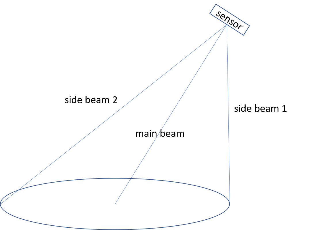
A: If the μLanding is tilted relative to the ground, it could detect any target within μLanding ' FoV, and the reading depends on μLanding antenna's beam, FSPL(free space path loss), target's RCS (radar cross section, basically it is decided by material and shape of target). For example, in the following plot, assuming the ground is flat and has a constant RCS everywhere. Side beam 1 direction has the least FSPL, but less radiation signal; while main beam direction has the strongest radiation signal, but FSPL is larger. The final reading from our radar can be any distance within main beam direction and side beam 1.

μLanding's FoV when it is tilted
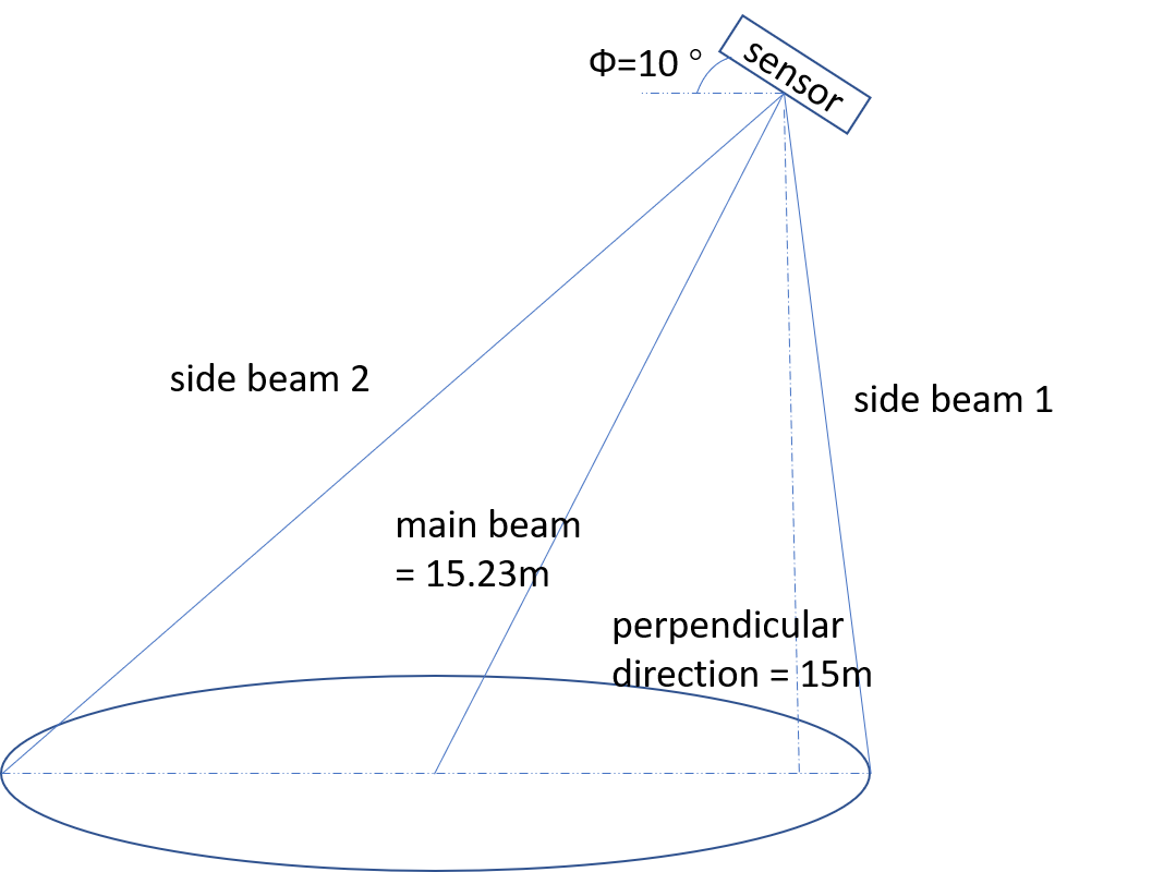
If uLanding is placed at AGL 15m and is tilted by 10 degree (it is within the radar's FoV), the distance reading from uLanding could be any number between 15m (perpendicular direction) and 15.23m (main beam direction, 15m/cos(10°)).

An example when μLanding is tilted
Q7: What is the shape of μLanding's FoV, and what is the footprint of μLanding on the ground?
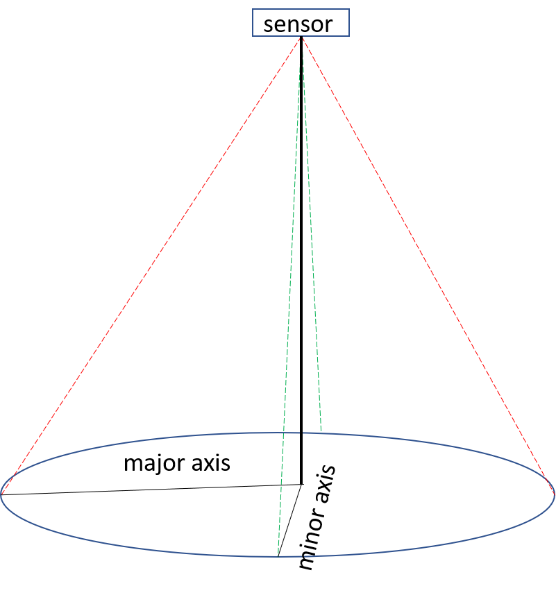
A: The shape of μLanding's FoV is more like a 'cone'. The footprint on the ground is a 'ellipse' shape.

μLanding's FoV and footprint on the ground
Q8: What is the difference of μLanding and Lidar product in terms of FoV (Field of View)?
A: One of the main difference between μLanding and Lidar is: Lidar has very narrow beam (FoV), while μLanding has wider beam (FoV) . In that case, Lidar usually has more accuracy for distance in simple scenario such as flat and smooth surface, while μLanding has more accurate reading in complex scenario, such as water surface, grass surface, crop canopy, mountainous setting. That's why we have a lot of customers in precision agriculture drones and water sports vehicles.
Updated almost 8 years ago
